Promotional Material
Disponibiliza o novo desdobrável promocional da Via Navegável do Douro, editado pela APDL-VND.
Mapa-resumo da Via Navegável do Douro, com informação simplificada dos cais fluviais, sua localização e serviços neles disponíveis.
Interesting facts
The Douro is considered a commercial waterway with internationl modern characteristics
Since time immemorial, the Douro River has been an important means of communication and transport for the region's products, being the only access route until the end of the last century. Records of the use of this river and a deep knowledge of its course can be found in documents from the Roman occupation period.
The history of the Douro region reflects the evolution of vessels and transport on this river: from the granting of ferry boats, to the cork rafts that floated down the river loaded with goods for Porto, to the muleteers (a hundred of them, with their regiment in the Lamego Chamber in the 16th century).
Until 1887, when the railway line was completed, the river was the only route used.
In the last century, according to a contemporary writer, "neither cart roads nor horse trails allowed uninterrupted travel along these steep riverbanks."
-
River navigation was dangerous and fraught with difficulties, to the extent that the Douro was referred to as "the river of difficult navigation."
The steep gradient of the river, sharp bends, protruding rocks, violent currents, numerous irregularities, rapids, and countless "jumps" or "pools" made navigation a perilous adventure.
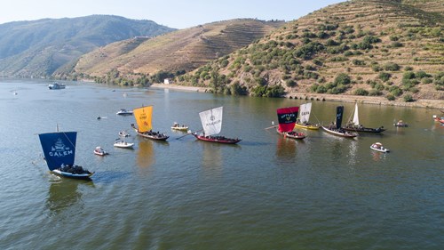
The rabelo boat was designed with features suited to this river and specifically for transporting barrels of wine, with references to its existence found in documents from the 10th century.
In addition to wine, rabelos carried general cargo and people.
They were steered with a large oar at the stern, known as the espadela, and used oars for propulsion when going downstream and a large sail for going upstream.
When the wind was insufficient, the boat was hauled "à sirga," meaning by hand with ropes from the riverbanks, or with oxen.
Thousands of rabelos navigated up and down the river (over 3,000 in some years) with great suffering, courage, and tenacity from the men of these lands.
The barrels were not filled completely to ensure they could float, given the frequent accidents.
-
The first major hydraulic work undertaken in this region was the demolition of the Cachão da Valeira between 1780 and 1791, an insurmountable obstacle to navigation.
This represents a highly significant historical milestone in the navigability of the Douro River, as it extended navigation upstream to Barca d'Alva, which allowed for the expansion of vineyards in the Upper Douro region up to the Spanish border.
It was the communication route that created the conditions for development, not the other way around; that is, the need for wine exportation did not precede the demolition of the Cachão.
The Cachão da Valeira also gained notoriety for the drowning of Baron de Forrester, a scholar and enthusiast of the Douro, 70 years after its demolition. He had created a map of the river on which he noted 210 "points."
-
Work was carried out to deepen and widen the navigation channel downstream of the hydroelectric installations, and several river quays were constructed.
The commercial port of Sardoura, with an 80-meter-long quay wall and 1.6 hectares of backfill, and the commercial port of Lamego, with a 160-meter-long quay wall and 6.5 hectares of backfill, were completed in 1988 and 1989, respectively.
On October 10, 1986, the first tourist vessel, the "RIBADOURO," arrived in Régua.
On October 19, 1990, the navigable waterway was inaugurated in its entirety by a tourist vessel that reached Barca d'Alva, the "TRANSDOURO."
On February 15, 1992, the commercial ship "SEA ELBE" inaugurated the Sardoura port, and on April 7, 1994, a river-sea vessel, the "MARAIKA," docked for the first time at the commercial port of Lamego.
On April 20, 2003, the river-sea vessel "HANSA-LYON" inaugurated the port of Várzea do Douro.
-
With the development of rail and road communications, traffic on the river declined, and by 1961, only 6 rabelos were operating permanently on the Douro.
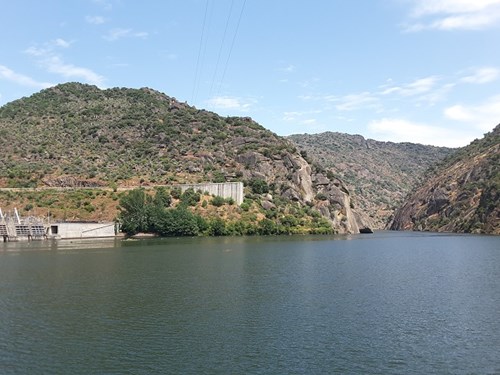
Between 1961 and 1986, the hydroelectric utilization of the Douro National was carried out.
The construction of dams created large reservoirs of calm water, which provided immense opportunities for modernizing the navigable waterway.
If we exclude periods of flooding, we can say that the river has been tamed definitively, and the navigation difficulties have disappeared.
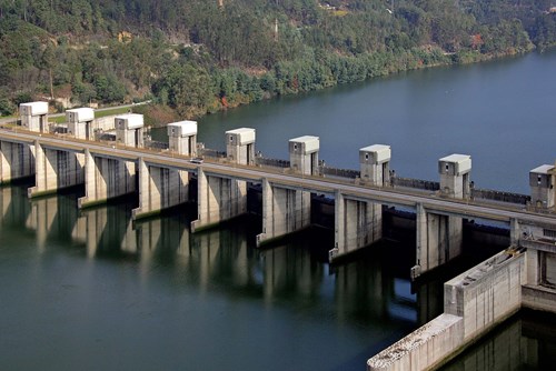
Each dam included a lock with dimensions allowing the passage of large vessels (83 meters in length, 11.40 meters in width, 3.8 meters in draft, and a transport capacity of up to 2,500 tons).
The Carrapatelo Project, the first hydroelectric development constructed in 1971, was equipped with one of the largest locks in the world, overcoming a height difference of 35 meters.
It was the first national achievement in this field and, due to its grandeur, also represents another milestone in the history of navigation on the Douro. This was followed by the Régua (1973), Valeira (1976), Pocinho (1983), and Crestuma (1986) developments.
-
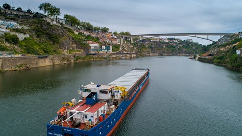
Regarding the traffic of goods, despite the significant constraint of the uncertainty surrounding the condition of the Barra, river-sea vessels are now reaching the port of Lamego.
The number of these vessels navigating up the Douro has also been increasing.
Although primarily based on granite transportation, commercial navigation generates significant added value for the region by economically enabling quarry exploitation and creating jobs in depressed areas.
-
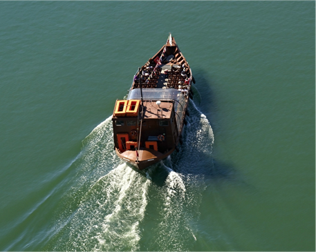
Approximately 186 vessels operate on the Douro, offering a wide range of tourist experiences, from short sightseeing tours (such as the Porto and Gaia bridges or the World Heritage tour) to luxury hotel boat cruises from Porto to Barca d'Alva.
There has been a noticeable trend of growth in both the number of river tourists and the fleet of vessels available for tourist cruises. Along the river, municipalities and APDL have been enhancing and constructing tourist river quays equipped with facilities for high-quality tourism.
In almost all municipalities, projects are either completed or underway to, on one hand, accommodate river tourists and, on the other, attract riverside communities to the river.
-
River-sea transportation of goods offers significant economic and environmental advantages, and it is already possible for large commercial vessels to reach Régua (105 km of navigable waterway).
It costs as much to transport 1,500 tons of granite from Pedras Salgadas to Leixões by road as it does to ship it to Rotterdam using the Douro, with the advantage of being ten times less polluting.
Regarding the type of products transported, granite remains almost exclusively dominant, coming from quarries in Alpendorada, Pedras Salgadas, Viseu, and Aguiar da Beira in terms of exported products.
For upstream traffic, rare granites from Northern Europe have been imported, unloaded in Sardoura to be processed and potentially re-exported. There is an expectation of new products being handled at the Douro ports.
Discussions are underway with various businesspeople regarding the import of timber, cement, Ytong, iron, and fertilizers by river, and the export of feldspar in addition to granite. Due to siltation at the bar, it is common for commercial vessels chartered for the ports of Sardoura and Lamego to be unable to navigate up the Douro, despite APDL - Douro Navigable Waterway maintaining costly dredging at the Douro bar. The construction of jetties at the mouth of the Douro River is becoming essential. Additionally, there is a need to proceed with the widening and deepening of the navigable channel near the mouth of the Tua River, which will allow large commercial vessels to reach the end of the waterway. The total cost of these two projects is estimated at 45 million euros.
-
Alongside tourism and commercial navigation, recreational boating has significantly increased.
Several initiatives in the field of water sports, such as rowing, sailing, canoeing, and motorboating, have been carried out with the support of APDL - Douro Navigable Waterway.
Regarding recreational boating, there has been a substantial increase in the number of passengers and vessels using the locks, which can be attributed to the growing interest in river tourism and the commissioning of new docks equipped with support services and facilities.